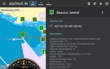
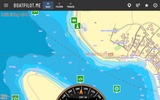
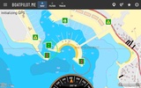
BoatPilot: Chartplotter is an integrated maritime navigation app designed to enhance your sailing experience with advanced mapping and community features. As an ideal replacement for traditional chartplotters, the app offers comprehensive sea maps across the European part of the Mediterranean, from Spain, including the Canary Islands, to Greece. With these detailed charts, you can easily plan and navigate your sailing trips.
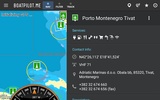
The app allows you to create and save custom routes, record your tracks, and maintain a digital journal of your adventures. You have the option to share these details with friends or team members via email and social networks, making it easier to stay connected, even when you are at sea. The built-in community functions enable you to contribute to and enrich the database by adding points of interest (POIs), photos, and comments, fostering a collaborative environment among sailors.
For businesses, adding your services to the map can significantly increase visibility and attract more customers by targeting the maritime community directly. Furthermore, it supports integration with various WiFi adapters to display real-time navigation data such as speed, depth, radar outputs, and AIS directly on your tablet.
The app is continuously updated, offering access to the latest maps and features without additional cost. Whether you're planning a leisurely sail around the Mediterranean or looking to enhance your maritime business, BoatPilot: Chartplotter provides a robust solution with its user-friendly interface and diverse functionalities. You are equipped with all the essential tools to ensure a safe and enjoyable sailing experience.
Requirements (Latest version)
- Android 5.1 or higher required






Comments
There are no opinions about BoatPilot: Chartplotter yet. Be the first! Comment